
Description
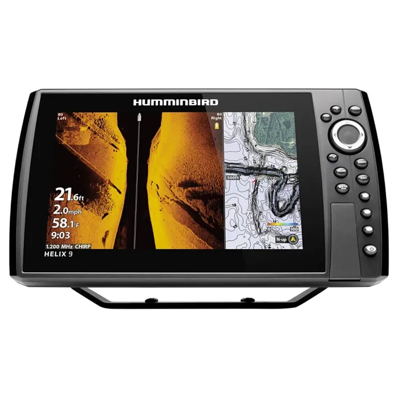
The Helix 9 MSI+ GPS G4N features a 9″ display, MEGA Side Imaging+, MEGA Down Imaging+, Dual Spectrum CHIRP Sonar and internal GPS with Humminbird Basemap. As with all Helix G4N models, this Helix 9 includes standard features such as AutoChart Live, NMEA 2000, in addition to Bluetooth and Ethernet networking for compatibility with the One-Boat Network family of products from Humminbird, Minn Kota and Cannon.
Keypad Control: Master Helix at the touch of a button. Access the preloaded views from the user-friendly menu system, operated by soft key controls that allow you to reliably operate your fish finder in any conditions.
MEGA Side Imaging+: See the world below like never before with a crystal-clear Side Imaging viewing out to 200′ on either side of your boat. You’ll unlock more fish and structure with 20% more detail and 60% more range capability than MEGA Side Imaging sonar.
MEGA Down Imaging+: Get unprecedented underwater clarity with Down Imaging coverage down to 200′ below your boat. You’ll unlock more fish and structure with 20% more detail and 60% more depth capability than MEGA Down Imaging sonar.
Dual Spectrum CHIRP sonar: Before you cast, know what’s down there thanks to highly-detailed fish arches and a clear view of fish-holding structure and the bottom. Powered by the proprietary, Low-Q CHIRP transducer, Dual Spectrum offers two ways to search; Wide Mode for maximum coverage and Narrow Mode for focusing on the slightest detail.
Internal GPS and Humminbird Basemap: The enhanced basemap provides you with a clear view of underwater terrain and surrounding points of interest so you can fish and navigate with total confidence. Identify buoys, day markers, hazards, marinas, contours, depth markers and much, much more. Includes charts of more than 10,000 lakes, plus coastal coverage for the continental U.S.
Premium Chart Compatible: Humminbird provides the most complete offering of premium chart options to anglers everywhere. Get a complete view of the world below with optional charts from Humminbird’s LakeMaster and CoastMaster products, as well as your choice of compatible Navionics charts.
AutoChart Live: Create real-time maps of your fishing spots, with access to patented Humminbird LakeMaster features. Map depth contours, bottom hardness and vegetation as you drive your boat. Comes standard with eight (8) hrs of built-in recording time and is compatible with AutoChart Zero Line SD cards for virtually-endless AutoChart Live mapping capacity.
One-Boat Network Compatible: Many Humminbird models seamlessly integrate and communicate with Minn Kota and Cannon products to unlock more features and capabilities for anglers everywhere. Make the more of your time on the water with the exclusive boat control and fish-catching features of the One-Boat Network.
Ethernet Networking: High-speed Ethernet allows you to build a powerful, professional-grade fishing system. Easily connect multiple fish finders, or upgrade to add-on technologies like Minn Kota i-Pilot Link and Humminbird CHIRP Radar.
Bluetooth: Take control right from the screen of your Humminbird with wireless communication to compatible Talon and Raptor shallow water anchors, as well as Cannon Optimum downriggers. Additional features include wireless software updates from the Humminbird FishSmart App and display of smart phone notifications on your Humminbird.
NMEA 2000 networking built-in: Connect an accessory NMEA 2000 network to your control head for even more information; from boat performance to weather and water conditions, make sense of it all with NMEA 2000 networking.
Includes control head, screen cover, transom mount transducer and mounting hardware, power cable, gimbal mounting bracket.
MEGA live imaging, networking, down imaging, built in GPS, Bluetooth, side imaging, dual spectrum CHIRP, built in mapping, MEGA imaging+
High definition display
Dual micro-SD slots
Ethernet networking
Wi-Fi
MEGA Live Imaging: MEGA Live delivers the clarity and detail of MEGA Imaging in live-action, allowing anglers to see fish and structure in real-time
MEGA Side Imaging+: MEGA Side Imaging+ extends out to 200′ on either side, plus 20% more detail than MEGA Side Imaging
MEGA Down Imaging+: Extended depth down to 200′, plus 20% more clarity than MEGA Down Imaging
CHIRP Digital Sonar: CHIRP stands for “Compressed High Intensity Radar Pulse”. By covering a wide range of frequencies, CHIRP produces more accurate, more detailed returns of fish, structure and the bottom
Dual Spectrum CHIRP: Dual Spectrum CHIRP Sonar – By covering a wide range of frequencies, CHIRP produces more accurate, more detailed returns of fish, structure and the bottom
MEGA 360 Imaging: MEGA 360 Imaging sweeps up to 125′ in every direction around your boat to deliver the clearest images of structure, the bottom and fish, even while you’re sitting still
Precision GPS: Precision GPS provides an accurate position fix, meaning more accurate waypoints and boat positioning for better fishing
Humminbird Basemap: Humminbird Basemap – Based on freshwater data from LakeMaster and NOAA, these maps provide a clear view of underwater terrain. Identify buoys, daymarkers, hazards, marinas and countless other navigation aids and points of interest. You’ll also see contours, depth markings and, for coastal areas, spot soundings
AutoChart Live: Map the water as you drive the boat and keep the data stored on your fish finder or import it into the AutoChart PC program
LakeMaster: LakeMaster lake maps include unrivaled, easy-to-read contours, highlighted depth ranges, scrollable lake lists and more
LakeMaster PLUS: These maps include all of the features of LakeMaster with one key addition: aerial photography of high definition lakes, providing visibility to docks, buildings and structure
SmartStrike: SmartStrike cards combine High Definition LakeMaster lake map data and extensive search algorithms to help you pattern and locate fish at any time of the year
CoastMaster: CoastMaster maps deliver unrivaled nearshore and offshore fishing performance
NMEA 2000: NMEA 2000 – Easily connect bearing, depth, engine status, tank level and electrical sensors with Humminbird NMEA 2000 Networking
AIS: Track other vessels with Humminbirds state-of-the-art AIS technology. It takes the risk and guesswork out of navigating high-traffic channels or low-visibility seas
CHIRP Radar: Compatible with Humminbird CHIRP radar
Humminbird Autopilot: Set your heading or turn pattern and maintain your desired route, regardless of speed or sea and wind conditions
Bluetooth: Enable features like wireless software updates and map transfers from the Humminbird FishSmart App and also keep your phone out of the water and in your pocket by displaying notifications on your Humminbird
One-Boat Network: One-Boat Network allows Humminbird, Minn Kota and Cannon products to seamlessly integrate and communicate – unlocking more features, capabilities and potential for anglers
Compatible With: Minn Kota US2 Sonar, Minn Kota Built-In MEGA DI, Minn Kota Talon/Raptor, Minn Kota i-Pilot Link, Minn Kota Built-In MEGA SI, MEGA Live, AIS, NMEA 2000, MEGA 360, Radar, AutoPilot, One-Boat Network
Specifications
Series: Helix
Display Size – Diagonal: 9″
Display Pixel Matrix: 1024H x 600V
Transducer Included: XM 9 HW MSI T
Features: MEGA Live Imaging, Networking, Down Imaging, Built In GPS, Bluetooth, Side Imaging, Dual Spectrum CHIRP, Built In Mapping, MEGA Imaging+
Memory Card Slot: Dual Micro SD
Sonar-Standard: Dual Spectrum CHIRP, MEGA Side Imaging+, MEGA Down Imaging+
Sonar-Coverage: 20°, 42°, 60°, (2) 86° & (2) 55° @ -10dB
Sonar-Optional: 50 kHz, 50/Low Airmar CHIRP
Live Sonar-Coverage: 20° x 120°
CHIRP – Frequencies Supported: Narrow Mode (180-240 kHz), Wide Mode (140-200 kHz), Full Mode (150-220 kHz)
Sonar-Frequencies Supported: 50/83/200/455/800 kHz & 1.2 MHz
Depth-Sonar: 3,500′ (optional 50 kHz), 1,200′ (standard transducer)
CHIRP – Imaging Frequencies Supported: MEGA DI+ (1100-1200 kHz), 800 kHz SI+ (780-840 kHz), 455 kHz SI+ (405-505 kHz), 800 kHz DI+ (800-860 kHz), 455 kHz DI+ (435-535 kHz), MEGA SI+ (1050-1175 kHz)
Depth-Down Imaging: 200′ (MEGA), 400′ (455 kHz), 125′ (800 kHz)
Range-Side Imaging (Side-To-Side): 800′ (455 kHz), 250′ (800 kHz), 400′ (MEGA)
Interface: Keypad Control
Power Draw: 2.4 Amps
Power Input: 10.8-20 VDC
Power Output Peak-to-Peak: 8000w
Power Output RMS: 1000w
Screen Snap Shot: Included
Sonar Recording: Included
Mount-Standard: Gimbal
Mount-Optional: In-Dash Mounting Kit
Transducer Mount Location: Transom
GPS Chartplotting: Included
GPS Receiver: Internal
GPS Trackplotting: Included
Waypoints, Routes, Tracks/Points: 2,750, 47, 50/20,000
360 Imaging Compatibility: Yes
MEGA Live Compatibility: Yes
Humminbird Basemap: Included
LakeMaster Compatibility: Yes
CoastMaster Compatibility: Yes
Navionics Gold/HotMaps Compatibility: Yes
Navionics Platinum+ Compatibility: Yes
Platinum Compatibility: Yes
Minn Kota i-Pilot Link Compatibility: Yes
Minn Kota Talon Shallow Water Anchor Compatibility: Yes
Radar Compatibility: Yes
5-Port Ethernet Switch Compatibility: Yes
AIS Compatibility: Optional
Autopilot Compatibility: Yes
Heading Sensor GPS Compatibility: Yes
NMEA2000: Included
Target Separation: 2.5″
Interference Rejection: 6 Modes
Noise Rejection: 6 Steps
Upgradable Software: Yes
View Preset Keys: Yes
X-Press Menu System: Yes
Custom Digital Readout: Yes
Custom View Selections: Yes
Display Colors Grayscale: 16-Bit
Display Type: Color TFT
Speed: Included
Temperature: Built In
Temperature Alarm: Yes
Temperature Graph: Yes
Warranty: 2 Years Warranty
Mount-Standard Size
Width: 12″
Height: 7″
Depth: 4.13″
Mount-Optional Size
Width: 12″
Height: 6.63″
Depth: 1.32″
Reviews
There are no reviews yet.