
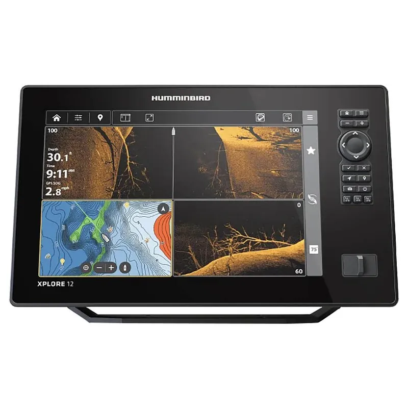
Description
The XPLORE Series is lightning-quick and laser-focused on anglers favorite features. Find your fishing spots faster with included LakeMaster and CoastMaster charts. Sync 10,000 fish spots with custom colors and icons to your phone through a new waypoint management system. Get the clearest picture of what’s below with compatibility for the best sonar, including MEGA Live 2 forward-facing sonar. Connects to Minn Kota products and control them on command – from enabling Advanced GPS navigation to deploying shallow water anchors with One Boat Network compatibility. With the most advanced technologies and easy-to-use interface, there’s more to XPLORE.
Control Head Only Model: This model does not include a transducer. This CHO model is a great choice for those looking to connect to connect to Built-in MEGA Imaging on Minn Kota trolling motors, accessory transducer options like MEGA 360 Imaging or share sonar data from an existing Humminbird Ethernet network control. Easily access the preloaded views from the user-friendly menu system, operated by touch screen or directional key pad to reliably operate your fish finder in any conditions
MEGA Side Imaging+: See the world below like never before with a crystal-clear Side Imaging viewing out to 200′ on either side of your boat. You’ll unlock more fish and structure with 20% more detail and 60% more range capability than MEGA Side Imaging sonar
MEGA Down Imaging+: Get unprecedented underwater clarity with Down Imaging coverage down to 200′ below your boat. You’ll unlock more fish and structure with 20% more detail and 60% more depth capability than MEGA Down Imaging sonar
Industry-leading Humminbird Sonar: Equipped with MEGA Side Imaging+, MEGA Down Imaging+ and Dual Spectrum CHIRP sonar to keep you on the fish. MEGA Imaging+ provides views up to 250′ under and out to either side of your boat and Dual Spectrum CHIRP shows exceptional 2D sonar with superior target separation and fish clarity
Internal GPS and Humminbird Basemap: The enhanced basemap provides you with a clear view of underwater terrain and surrounding points of interest so you can fish and navigate with total confidence. Identify buoys, day markers, hazards, marinas, contours, depth markers and much, much more. Includes charts of more than 10,000 lakes, plus coastal coverage for the continental U.S
Premium Chart Compatible: Humminbird provides the most complete offering of premium chart options to anglers everywhere. Get a complete view of the world below with optional charts from Humminbird LakeMaster and CoastMaster products, as well as your choice of compatible Navionics charts
Includes LakeMaster and CoastMaster VX map card with U.S. and Canada regions standard data
AutoChart Live: Create real-time maps of your fishing spots, with access to patented Humminbird LakeMaster features. Map depth contours, bottom hardness and vegetation as you drive your boat. Comes standard with eight (8) hrs of built-in recording time and is compatible with AutoChart Zero Line SD cards for virtually endless AutoChart Live mapping capacity
One-Boat Network Compatible: Many Humminbird models seamlessly integrate and communicate with Minn Kota and Cannon products to unlock more features and capabilities for anglers everywhere. Make the most of your time on the water with the exclusive boat control and fish-catching features of the One-Boat Network
Ethernet Networking: High-speed Ethernet allows you to build a powerful, professional-grade fishing system. Easily connect multiple fish finders or upgrade to add-on technologies like Minn Kota i-Pilot Link and Humminbird CHIRP Radar
Bluetooth: Take control right from the screen of your Humminbird with wireless communication to compatible Talon and Raptor shallow water anchors, as well as Cannon Optimum downriggers. Additional features include wireless software updates from the Humminbird One-Boat App and display of smartphone notifications on your Humminbird
NMEA 2000 Networking Built-in: Connect an accessory NMEA 2000 network to your control head for even more information; from boat performance to weather and water conditions, make sense of it all with NMEA 2000 networking
Specifications
Model: XPLORE 12 CHO Fish Finder
Series: XPLORE
Display Size – Diagonal: 12.1″
Length: 8.46″
Height: 14.15″
Width: 3.4″
Weight: 6 lb
Display Pixel Matrix: 1280H x 800V
Compatible With: Minn Kota US2 Sonar, Minn Kota Built-In MEGA DI, Minn Kota Talon/Raptor, Minn Kota i-Pilot Link, Minn Kota Built-In MEGA SI, MEGA Live, NMEA 2000, MEGA 360, Radar, AutoPilot, One-Boat Network, MEGA Live 2
Features: Touch Screen, Networking, Down Imaging, Built In GPS, Bluetooth, Side Imaging, Built In Mapping, MEGA Imaging+, Wi-Fi, MEGA Imaging
Memory Card Slot: Dual Micro SD
Sonar-Standard: Dual Spectrum CHIRP, MEGA Side Imaging+, MEGA Down Imaging+
Sonar-Coverage: 20°, 42°, 60°, (2) 86° & (2) 55° @ -10dB
Sonar-Optional: 50/83/200 kHz, Airmar High, High Wide, Medium, Medium Wide and Low
CHIRP – Frequencies Supported: Narrow Mode (180-240 kHz), Wide Mode (140-200 kHz), Full Mode (150-220 kHz)
Sonar-Frequencies Supported: 50/83/200/455/800 kHz, HW DSC CHIRP and MEGA
Depth-Sonar: 3,500′ (optional 50 kHz), 1,200′ (standard transducer)
CHIRP – Imaging Frequencies Supported: 455 kHz SI+ (405-505 kHz), 455 kHz (420-520 kHz), MEGA SI+ (1050-1175 kHz)
Depth-Down Imaging: 200′ (MEGA), 400′ (455 kHz)
Range-Side Imaging (Side-To-Side): 800′ (455 kHz), 400′ (MEGA)
Interface: Touch Screen, Keypad Control
Power Draw: 2.4 Amps
Power Input: 10.8-20 VDC
Power Output Peak-to-Peak: 8000 w
Power Output RMS: 1000 w
Screen Snap Shot: Included
Sonar Recording: Included
Mount-Standard: Gimbal
Mount-Optional: In-Dash Mounting Kit
Transducer Mount Location: Transom
GPS Chartplotting: Included
GPS Receiver: Internal
GPS Trackplotting: Not Supported
Waypoints, Routes, Tracks/Points: 10,000, 50, 50/20,000
360 Imaging Compatibility: Yes
MEGA Live Compatibility: Yes
Humminbird Basemap: Included
LakeMaster Compatibility: Yes
CoastMaster Compatibility: Yes
Navionics Gold/HotMaps Compatibility: Yes
Navionics Platinum+ Compatibility: Yes
Platinum Compatibility: Yes
Minn Kota Advanced GPS Navigation Compatibility: Yes
Minn Kota i-Pilot Link Compatibility: Yes
Minn Kota Talon Shallow Water Anchor Compatibility: Yes
Radar Compatibility: Yes
5-Port Ethernet Switch Compatibility: Yes
AIS Compatibility: Optional
Heading Sensor GPS (NMEA 2000) Compatibility: Yes
NMEA2000: Included
Target Separation: 2.5″
Upgradable Software: Yes
View Preset Keys: Yes
X-Press Menu System: Yes
Custom Digital Readout: Yes
Custom View Selections: Yes
Display Colors Grayscale: 24-Bit
Display Type: Color TFT
Speed: Included
Temperature: Built In
Temperature Alarm: Yes
Temperature Graph: Yes
Warranty: Two Years Limited Warranty
Mount-Standard Dimensions
Width: 14.145″
Height: 8.911″
Depth: 3.989″
Mount-Optional Dimensions
Width: 14.145″
Height: 8.911″
Depth: 3.989″
Reviews
There are no reviews yet.